Song of the Day: Beautiful Day — U2
“You’re on the road / but you’ve got to destination / You’re in the mud / In the maze of her imagination… It’s a beautiful day / don’t let it get away”
While it was a difficult day, today also was a beautiful day. Properly in the Appenines, I was treated to vistas back over the rolling foothills and beyond to mountains ad infinitem…of course, I had to work for these views…
Note: I apologize for the delay in posting these last few blogs! The hostels I have been staying in have had limited-to-no wifi. I’m also going to start posting twice a day with the hope that the blogs will “catch up” to me a bit now that I am falling behind.
I was up just after 6 with my alarm — even after spending some time awake in the middle of the night (our neighbors were singing loudly at 3am), I still got a solid 8 hours given the early bedtime. So, I was feeling relatively awake as I packed and patched up my feet in preparation for a serious day of climbing. I left the accommodations at 7 with the sun barely rising, setting out in search of food. At a bakery I purchased a bit of onion focaccia and a slice of pizza to keep in my bag, and at a nearby bar I had a cornetto and a cup of coffee before heading out.
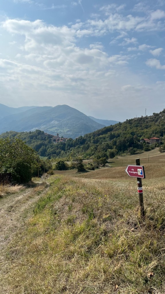
Immediately, I was climbing — not quite 200 meters on a winding road out of town, treated to beautiful views over the Taro valley from the top. This was a helpful warm-up to muscles that had forgotten what it felt like to climb after 10 days or so of flat walking. In what would become something of a pattern for today, as soon as I reached the top of the hill, the path began to descend again, reminding my knees what it feels to hurt. Near the top of this hill, I stopped at a water fountain for a drink and scoped out a Via Francigena map which promised water and food in many of the upcoming towns. A construction worker called out to me with some advice about where I could find a fountain and avoid some asphalt walking, but I didn’t hear what town his advice was for, and he turned back to work as I thanked him. It would remain a mystery.
So, I started the descent. It was still early morning light and before me was a gorgeous view of layers of mountains in the rising sun, and the path downward lined with trees. I stopped to take some photos, naturally, and bask in the beauty before winding my way down, knees wincing with every step. On the way down I passed two wood carvings — a knight and a bear — guarding a building. Other than that — no one.
Soon I was back at sea level-ish, walking on the side of a small state road. I hung my hi-vis from my bag for visibility, but there weren’t enough cars to cause concern. I followed the road comfortably through Sivizzano, the first town — which had no sign of water or food, despite the map earlier. Shortly after Sivizzano the signs pointed me off the road onto a path, though another sign noted that in the case of bad weather I should follow the road instead. The weather was good so I took the path. I remembered from the guidebook that this path involves fording a flood-prone stream multiple times — however in this extremely dry October, the stream was completely dry. I clambered up the bone-dry riverbank and continued on through more scrubby sort-of-forest, before fording the “stream” again and reconnecting with the road. This marked the end of a few hours of relatively flat walking, and I was not quite yet halfway.
So, the uphill began. First, following a winding road up to the tiny hamlet of Bardone, where I found a water fountain and sat for awhile, eating the onion focaccia. It had started to get hot and my face was coated in a sheen of sweat that reappeared no matter how many times I wiped it away. And the walk to Bardone was only the beginning: then, a straight-uphill road walk to Terenzo, that wasn’t too steep but was substantial enough to leave me winded. I stopped for another break at Terenzo’s church, staring into the middle distance as I heard a drone buzz back and forth overhead. When I finally felt like I had the energy to continue, I made my way uphill out of town to find the path.
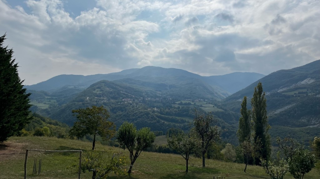
I had mentally prepared myself that the next section would be the most difficult — gaining 250 meters of unrelenting, straight-up elevation. And even so I was surprised to find myself face to face with a steep gravel track through the forest. As I made my way up, huffing and puffing, I delusionally kept telling myself that it would level out again soon and I would get a reprieve (it did not). Then, suddenly, I heard the crack of gunshots. I had heard them earlier from a distance — these were not so far away (but, sure, not so close enough to be genuinely scared). Either way, I made sure my hi-vis was visible and just in case started singing to announce my presence. I made my way through much of Taylor Swift’s early stuff, and realized the singing was taking my mind off the climb and my painful heel. Not a bad deal. And, finally, I was at the top of this first section. Rejoining the road briefly, I had a fantastic view deeper into the mountains — lush green, covered in forest, and continuing in fading layers as far as the eye can see. Closer up, I could see a tiny village with a large tower clinging to the hillside.
And, there was the path — heading down. So I quickly lost much of the elevation I had worked to hard to gain, making my way into the hamlet of Castello di Casola, whose only fountain was in someone’s backyard and had been roped off. To my absolute dismay, the path continued down even further from here, steep and covered in loose, slippery rocks. It’s one thing to take away my hard-earned altitude, but you don’t have to do it in such a difficult way… I carefully picked my way down, occasionally losing my footing and almost falling or rolling an ankle. At a certain point, the path forked — the signposting had been bad until now, but not problematically so, as I could use the app. But now, the app was no help, and the only sign marking the path was laying on the ground (and, ironically, had written on it “If you are unsure of the way, just use your nose”). So, with no other visible blazes, I picked the left path, which ended up being steep and rocky to the point of being genuinely dangerous. I almost injured myself multiple times — I regretted not just cutting over to the road, which I was going to rejoin soon anyway.
Eventually, a quick check of the app showed I had selected correctly from the two paths, and I emerged in the surprisingly wealthy-seeming hamlet of Casola Villa, with its recently renovated farmhouses. Here, thankfully, there was a fountain to douse my bandana before continuing. Having gained a good amount of elevation (even after the extended downhill), it was much cooler up here than in the valley — in the low 70s. Even so, I was drenched in sweat and hot from the exertion. And it was more uphill, but this time into a beautiful pine forest. The path itself was soft, carpeted in pine needles (nice) and pine cones (dangerous), and the woods were silent. Overhead, clouds had moved in, and the air cooled off ever so slightly.
I enjoyed this peaceful walk, even as I continued to gain more and more elevation. I will say, though, for any potential future pilgrims, that the sign-posting was not great, and diverged from the app. I ended up on the road, missing the app’s turn off, and then after a few hundred meters re-diverted myself into the pine forest. I had another fantastic view over the mountains, including large boulders called the Salti del Diavolo (Devil’s Jumps) due to their pointiness. I could also see Cassio just ahead of me — exciting, except that the path was continuing down, down, down….
Once again, this section was lovely, but poorly marked. Often I couldn’t see any VF blazes at a fork in the path, and the app also thought the path was a ways off to the side. But, using common sense (“clearly they want me going downhill, so I’ll just pick the path going down the fastest”) I managed to find the way. Here I was sharing the path evidently with a trail running route called the “Tartufo Trail Running.” After all, I guess it is truffle season! After nearly slipping on pine cones a few times, finally the descent ended and I began working my way back uphill. Even thought today was only 12 miles or so, I was totally spent by the time I got to this final stretch. It made me appreciative all the more for Sam and Patrick’s company in the Alps — surely I would have been much slower and much more tired, like today, had I been on my own.
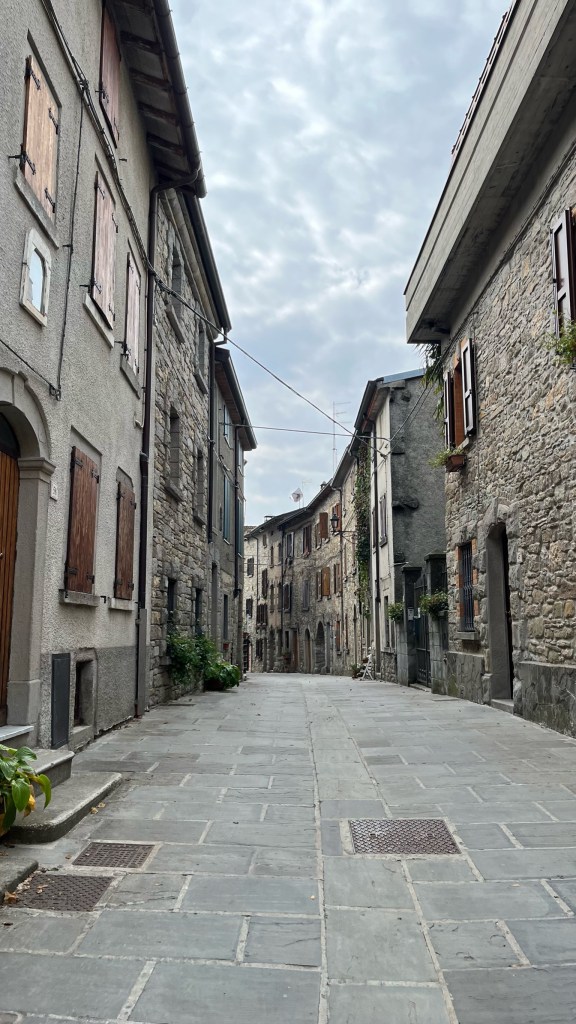
Leaving the forest, I climbed up through the backyards of Cassio and into the town’s charming (and tiny) medieval center. There seem to be a lot of collectors in town: one house had a bench out front covered in antique tchotkes, another’s front yard was full of Buddhist art, and a third house grew mini succulent gardens in Moka pots. Admiring these shows of personality, I cut over to the main road in search of the only open place in town — a bar called Il Vecio. And it was a fantastic spot! I sat outside with a view to the mountains, and was brought a lunch of testaroli al pesto (really more of a Ligurian dish I think, but they were delicious — testaroli is a sheet with consistency almost like injera, cut into squares and served like a pasta) and a small iced Coke (alla spina, not from a can or bottle!). The caffeine was probably not the best for me, but I figured I am so tired and the drink was so small I’ll probably be all right — and a bit of caffeine to address my incoming headache (and sugar and ice to reconstitute the rest of me) was very welcome.
A French couple pulling a trolley sat nearby, and I said hello. Unfortunately, my French has reverted to being very poor now that I get to speak Italian instead. But I discovered that they started their journey mid-August, in Bourgogne. I offered them the email of tomorrow’s hostel, and headed over to check in at the Ostello di Cassio.
The woman who runs the place with her husband was lovely and quickly took me under her wing. She and her husband took this place over from the last owners, who (I have heard) was essentially a hoarder and gave the place a very weird vibe. Thankfully, now it is a clean, normal hostel with plenty of space. All the eateries in town are closed, so everyone planned to eat dinner together — though she warned me these would be pre-made microwave meals. I pre-ordered a chicken sandwich and a beer. The owner, conspiratorially, told me quietly that apparently a famous Italian YouTuber would be joining tonight. I headed upstairs to the room I was sharing with with Monique and Alain, the French couple from earlier, and an Italian couple named Corrado and Giordana. Monique speaks Italian, so the five of us were able to converse in Italian, sparing everyone the experience of my terrible French.
Dinner was hilarious — the Italians were deeply offended by the dinner of microwaved risotto and wine of unspecified origin (“Merlot d’Italia — di dove? — d’Italia!” *waving of hands*). I had pre-ordered a sandwich of a frozen chicken cutlet that was moderately less offensive to my (less cultured, American) palate. The YouTuber (who, as it turns out, has met Sam before at an event) was a very nice guy from Bergamo. One of his friends is the bassist of one of the most famous Italian bands — I thought they were messing with us, but turns out he really was. They were very cool and we chatted a bit about the Via, but also about Italy in general.
The three young men had strong opinions on Tuscany, for example (we will cross into Tuscany after the Cisa Pass). “Tuscany is not representative of Italy, you have to remember this,” they warned me. I thought for a moment that they meant that Tuscany is like a Disneyland version of Italy. Not quite — they meant it as a pejorative. And yet, as we continued talking: “well, you’ll eat very well in Tuscany, the food is fantastic; oh yes, the scenery is nice, Tuscany is beautiful…”
“Aspetta,” I interrupted. “Quindi, la problema di Toscana è…?” And three voices immediately asserted “I Toscani!” The whole table dissolved into laughter. I still don’t understand their issue with Tuscans, but this is not the first time I’ve heard these somewhat random complains between regions. I’ll have to see what the Tuscans think of Lombardia (I’m sure it’s equally disdainful!)
Final mileage: 12.32mi
Walking time: 6h 03m
Elevation gain: 3,018 ft
Accommodation: Ostello di Cassio. Microwaved dinner aside (if the bar next door is open, I was very happy with their pasta so would recommend) I thought this was a nice place to stay. The rooms were clean and thoughtfully done, with enough space for everyone.


Leave a comment