Song of the Day: Mountains Beyond Mountains — Arcade Fire
“Sometimes I wonder if the world’s so small / That we can never get away from the sprawl / Living in the sprawl / Dead shopping malls rise like mountains beyond mountains / And there’s no end in sight / I need the darkness, someone please cut the lights”
A favorite song of mine, and one I associate strongly with Italy. It was on a “trains, planes, and automobiles” playlist I used to have and would listen to on transport. I listened to this song all the time riding the trains in Italy the summer I spent on the agriturismo, so the mountains I associate with this song are the Appenines. So, while it’s really a good train song (its beat mirrors the chugging of a regionale veloce), it was a perfect fit for today
With another pre-dawn alarm, I was up in the chilly morning, packing my bag. Heading downstairs, where the other pilgrims had already started breakfast, I was greeted to a warm welcome. They were curious as to when Nathan would arrive — I said I thought he was en route, but with limited service it was hard to tell. As we finished up our breakfast, his taxi pulled up and I ran out excitedly to greet him. At this point even the hostel proprietors knew he was coming, so they greeted him as a celebrity and offered him coffee and breakfast while I finished packing.
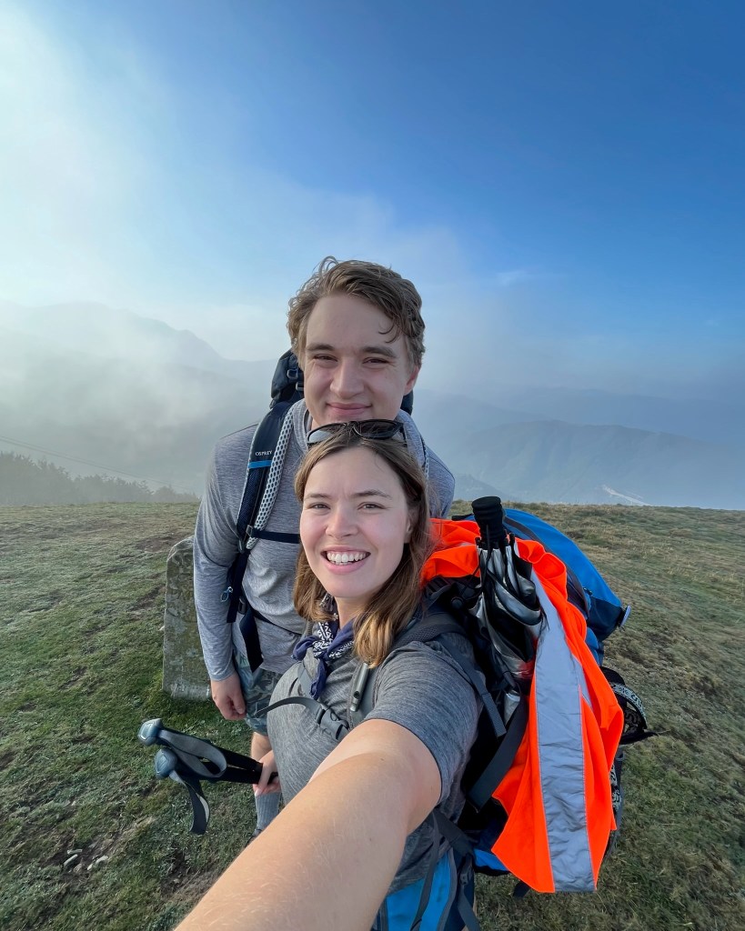
Once we were both ready, Nathan and I said our “a dopo”s to Alain and Monique and Corrado and Giordana, and headed out. The fog of yesterday morning hadn’t materialized, so I suggested that we do the quick detour to summit Monte Valoria, which was only going to add a few miles to a relatively short (12 miles per the app) day. So, we took off on the steep uphill I had come down yesterday, Nathan quickly getting ahead of me with his long legs. It’s been 2 months since we last saw each other, so it was nice to get back into the routine, catching up on what we had missed.
It took about 30 minutes or so of uphill to reach the top of Monte Valoria, a wind-swept, grassy peak of 1224 meters. We had a view to the mountains beyond, briefly, but soon after our arrival clouds began to roll in. Surrounded by white mist, we decided to sit down at a picnic table for a snack and to catch up. After awhile the clouds briefly parted and we jogged back to the summit for the view, before continuing along the ridge down towards Cisa Pass. After some confusion as to where he path was, we made our way down and into a misty forest. Once again, with the mist everywhere and the trees losing their leaves, it was a very spooky vibe — happy October. Making our way through a few gates that liberally used barbed wire, along a few more fields, we soon found ourselves rejoining the road.
We had arrived at the famous Cisa Pass, the border between Emilia-Romagna and Tuscany. The pass itself has a few buildings, a church, and an archway signifying the “gate to Tuscany”. It was largely deserted when we arrived, except for a few motorcyclists who soon continued on their way. We stopped into the only open Bar for a coffee and a tortelli, a half-moon pastry filled with jam. After sitting for awhile, we were ready to begin the descent.
In what would become something of a theme for the day, the descent really started with an ascent. We climbed up the set of stairs to the gate to Tuscany, stopping for a few photos and admiring the views of endless mountains ahead of us before plunging into the woods.
I think I’ve touched on the fact that the Apennines, despite the name, are very much “real mountains.” What became more and more clear today is that they are also much wilder than the Alps. In Switzerland, I was never too far out of earshot or sight of a road. Here, there was quickly no signs of civilization except for the trail. We meandered through beautiful, peaceful forests, the ground carpeted in leaves and tall trees creating a thick canopy above. Even more so in the Alps, it was easy to put ourselves in the shoes of medieval pilgrims, making the crossing of these mountains without modern navigation equipment.
After stumbling upon a picnic spot, we suddenly emerged onto a windy, exposed section. In all directions we had views of mountains: to the right, a highway bridge below us and tiny villages clinging to green hillsides; directly ahead of us, the spiny ridge of a massive peak; behind us, the already-impressive distance up to the pass. The views were truly spectacular as we picked our way down the grassy ridge. The dirt trail gave way to basically scree on a steep section, and I ended up slipping and falling, slow-motion, on my back, where I sat admiring the view until Nathan gave me a hand up. No damage done, we continued on (me somewhat more carefully) and made our way back into forest, where we happened upon Giardana and Corrado taking a break. We chatted for awhile and made plans for dinner this evening before Nathan and I continued.
Finally we entered our first village — really a hamlet. It was a collection of lovely stone buildings, well-preserved with that medieval mountain charm. A man came from his house as we stopped for water to ask where we were coming from and cheer us on. We thanked him and continued on the descent out of town.
Despite taking a prosciutto sandwich from the hostel this morning just in case, we were determined to eat a real meal to fuel the rest of our day. By this point Nathan and I had both noticed that even as the miles — and hours — ticked on, we didn’t seem to be getting much closer to Pontremoli. Accepting it would be a late arrival, it was better to eat well. So, we peered at a map as we interested the main road. A man in a tiny car pulled up and offered us directions to a trattoria. We made our way down, and as we walked in there he was! We greeted each other and Nathan and I sat down to eat. Next to us were none other than Monique and Alain, who had taken the road down and only had 7km left on the road. Nathan and I ordered a pasta al ragu each, and the waitress came with an absolutely massive pan of pasta — enough to feed a family of four. Starved, we made as big of a dent as we could before giving up and polishing off a refreshing lemon sorbet for dessert.
“Pausa pranzo” over, it was time to get back to the trail. Undoing our detour, we cut — uphill — on a small road up to another stone town called Previde, full of gorgeous buildings. From here we walked at length along a terrace, first with grassy backyards and then olive trees off to our right down the hill. After what felt like an eternity, and multiple times triple-checking the app to make sure we had gone the right way, we finally arrived in Groppodalosio, a charming village we had seen emerging from the mountainside. We were only briefly in the town before descending steeply past harvest vines to a beautiful Roman bridge. Looking below we could see a swim spot — after much debate we decided that getting down to the banks of the stream would be difficult enough that we may not make it back up, so we decided to admire it from above instead. At this point my feet were starting to hurt and Nathan — valiantly fighting jet lag — was clearly also starting to feel it. And yet, looking at the map, we still seemed to be only halfway down from the pass. And, it was starting to get hot.
From the bridge we followed a stony paved road — probably of Roman origin — up and down and up and down. With each uphill we guessed that we must be done with the ascent soon, only to be disproved. Back in more forest, we passed quickly through another village and caught up again with Giordana and Corrado, who had not stopped for lunch. After sharing our mutual complaints about the difficulties of the day, we set off together, crossing a series of Roman bridges over forest streams. We caught up with an elderly woman, slowly picking her way along one of the steeper uphills, cane in one hand and basket in the other. She was searching for mushrooms! Giordana chatted with her briefly before we continued up a hill and to another town with —- thankfully — an ice cold fountain. As I stopped to splash my entire upper body, Nathan took a photo of the sign. Population: 5.
It was hot now, and already relatively late — after 3pm — with no sign of arriving in Pontremoli anytime soon. Other than my first day in France, when I couldn’t start walking till the afternoon due to ferry timings, this would be my latest arrival. Nathan was starting to feel the mileage, and I was beginning to overheat. And yet, we still had more uphill to conquer, somehow. I exclaimed to Giordana — I thought this was supposed to be a downhill stage!
Setting off at a quick clip, we finally got through the actual end of the uphill, summittting a mountain topped by a cross, where we began to pull ahead of Giordana and Corrado. By now it was fully the afternoon, and we had already walked the 15 miles that I thought today would be in total — poor Nathan had accidentally been the victim of a bait and switch. On the way downhill through olive groves we made a bet of what the final mileage would be. Making our way through the town of Arzengio — suddenly, no longer a stone-clad mountain village, but the typical Italian pastel homes — we passed a group of elderly residents having a wine and chatting outside the church. Our knees were both aching, so we stopped at a water fountain to sit before the final descent. Mentally preparing to be done, in the meantime we enjoyed the views of the mountains in the golden afternoon light.
Leaving Arzengio we decided to take a shortcut down to Pontremoli, veering slightly off the Via Francigena and walking past farms with angry guard dogs. Soon we had a view of Pontremoli Cathedral’s green dome, which guided us to the Capuchin Convent where we were staying. Annoyingly, we arrived just as the distance ticked over to 17.1 miles — exactly Nathan’s guess. Winning the bet was, at least, some solace after a long day…for him.
In the end, this was one of the most physically difficult days I’ve had on the Via so far (not least because we ended up walking for about an hour more than anticipated due to the extra mileage). In addition to the length, the path had much more steep up-and-down than I had anticipated (this was partly my own fault for not looking more closely at the altimetric profile). The Cicerone guide book suggests doing an even longer stage from Berceto to Pontremoli — I cannot, in good conscience, recommend this based on my experience.
Making our way to our room in the convent, we tended to our wounds and Nathan got a first glimpse of the pilgrim post-walking life as I washed our clothes and laid them out to dry. I encouraged him to have some electrolyte water to rehydrate and offered advice for managing the immediate post-hike aches and pains. Soon he was out cold for a nap while I continued my chores and stretches.
At 6:30 we met up with Monique & Alain and Giordana & Corrado for an aperitivo, after Nathan had unsuccessfully tried to find flip flops to wear as camp shoes. After a glass of wine, our group located a trattoria with room for 6. Between the two of us, Nathan and I shared a truffle taglioni and a papardelle with wild boar ragu. The food was delicious and it was another lovely, lively pilgrim meal.
Exhausted and worn out, we limped back to the convent to get to bed. Tomorrow is expected to be a long day.
Final mileage: 17.10mi
Walking time: 6h 51m
Elevation gain: 2,975 ft
Accommodation: Convento Cappuccini. Right near the historical center of the town, and offers private rooms with private bathrooms for a reasonable price — I believe it was 30 euros as person.


Leave a comment