
Song of the Day: Take a Walk — The Head & The Heart
“Take a walk, try to relax, it’s not as bad as you think / Brush it off, she’ll call in the morning, it’s not as a bad as you think… why’s it so hard to find peace of mind / in the world when you’re given all of the time / just to find out, oh to find out?”
I say this for every song but…it’s a great walking song. And “try to relax” is exactly what I was telling myself while trying to hype myself up for a nerve-wracking section alone.
Today started with an early alarm and some amount of trepidation. It was still pitch-black outside at 5:30 when my alarm went off, and I packed my bags slowly and headed downstairs to eat breakfast, a stale brioche from yesterday. I got a message from Kerry saying that she and Andy would be heading out a bit later than expected, around 6:30 once it got light. This had been my plan as well so I figured I may catch them.
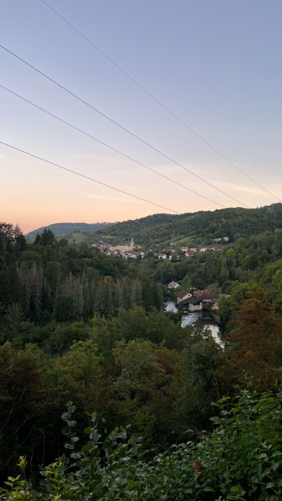
After finishing packing and a quick call with Nathan, I left cash and the keys for the pilgrim gite and was out into town. Exiting Mouthier I once again passed the church and epicerie in town, before heading down a very steep, gravelly downhill toward the Loue that had me carefully watching my footing.
Here was the first sign of what I was nervous about: a large sign announcing a deviation of the GR145, the path the Via Francigena follows in France. This was not news to me — the path had technically been closed since 2022, and there was much discussion about this in the pilgrim Facebook group. My understanding from a number of pilgrims was that by summer of 2023, the normal path (though technically closed) was in good shape and used by pilgrims and locals alike, while the deviation not only added an extra 6km, but was quite sketchy and dangerous in places. And it skipped the Source of the Loue, the highlight of this stage.
I had discussed with Patrick, who had passed this way a few days before, and then with Kerry and Andy yesterday and it sounded like taking the normal path was the plan. I felt good about this decision based on the information I had, but as a rule-follower at heart I did not enjoy the feeling of side-stepping signs saying “Trail closed for works, take deviation.”
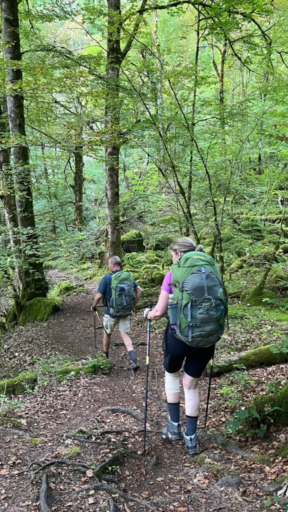
The path took me along the river, then up a steep gravel track through the woods, and onto a road. The road ducked down again and I passed a massive hydroelectric plant before picking my way onto a small path in the woods — one of the first proper trails of the VF. This path snaked up the hillside next to the river, with a steep drop off down to the cascades below. You could see the evidence of former landslides: downed trees and gravel that had fallen onto the track and been cleared. I started to get a bit nervous at this point and wished I had taken Kerry and Andy up on the offer to walk with them — even though the path was perfectly safe I would have preferred to do it with other people. But I had no idea if they were ahead of me or behind me, so I just had to push on.
After about 20 minutes I heard voices in the trees, looked up and — thank god! — there were Kerry and Andy. “You have NO idea how happy to see you,” I told them. We walked together for basically the rest of the day and it was fantastic! Andy would start out ahead while Kerry and I hung back and chatted, and we would stop periodically to admire the waterfalls from above and watch the sun as it began to hit the cliffs high overhead. I walked up front with Andy for awhile as well as we scrambled over rocks and continuing to climb up-valley.
Finally, we rounded a corner, passed a dam, and then we were there: the Source of the Loue. I wasn’t sure what to expect, really — it had been hyped up and when I first started researching the VF I didn’t think it was that big of a deal. However after having the Loue as a walking companion for two and a half days, it was very exciting to see where it originated. And the Source did not disappoint: from a gaping hole in one of the cliffs, water rushed out, cascading down rocks. I wasn’t expecting the spring to be quite so robust — it really was a treat.
After pausing for a snack outside the (closed!) restaurant by the source, we headed back into the forest briefly, skirted past Ouhans, and then headed on a long, steep uphill. We passed cows, bells tinkling as they munched on grass. We dove into a quiet pine forest, and stopped at a hunter’s cabin for water. We alternated between asphalt road (straight up, and really painful on such steep uphills) and soft dirt trails. Eventually, we reached the top and broke out from the woods.
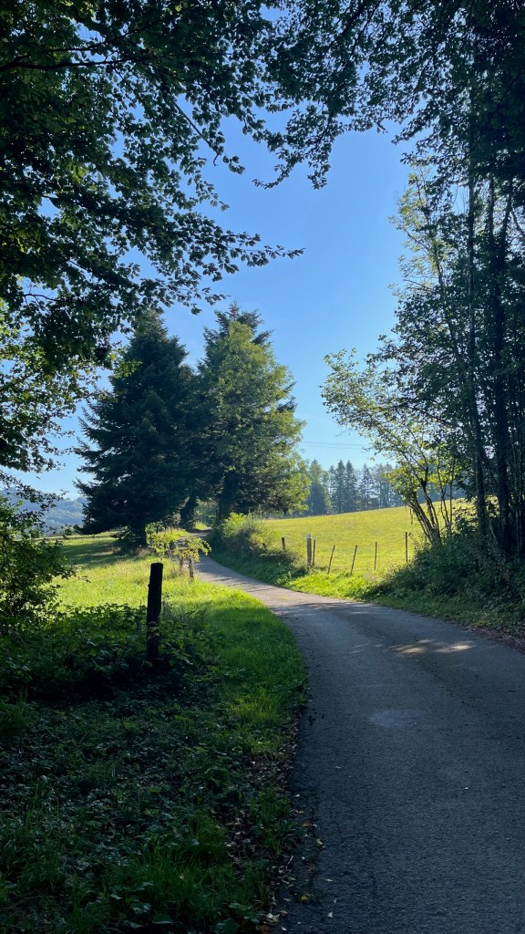
At this point we had over an hour of walking across rolling hills of green pastures, with more mountains silhouetted in the distance. It was really stunningly beautiful in a postcard kind of way: verdant, green, perfectly punctuated by trees and cows and winding roads. We paused for a bit for another snack and decided on a shortcut: per usual, the VF walked 2 sides of a triangle on the way into Pontarlier, briefly dipping into a town called Doubs. We could shave off a few kilometers and get out of the heat faster by going straight, which we decided to do.
From our resting spot in the shade it was maybe 45 minutes into he next village, Vuillecin, where we paused at a cemetery to get more water. At this point it was extremely hot, and the rest of the walk had really limited shade. I doused my bandana again to put on the back of my neck and prayed that my hat + sunscreen combination was protecting my face enough. From Vuillecin we walked along a D-road in the blazing sun — we’d spent the last few hours chatting about all sorts of things, but by this time each of us was quiet, just focused on getting to the next spot of shade. By the time we reached what the guidebook described as a “massive roundabout” (it was), we were all pretty beat. We passed through the underpass under the roundabout and then split off — I wanted to push onward to Pontarlier in search of a real lunch; Kerry and Andy headed to a sports store to see if they could find a hiking umbrella.
It was only 25 minutes or so through Pontarlier’s industrial and suburban outskirts, but the sun was beating down with limited shade. I pulled out my own umbrella and chugged water, just trying to force myself to push on. I finally arrived at the town’s famous Porte Saint-Pierre just a few minutes before 2pm, when most kitchens stop serving lunch. After discovering the Mairie was closed, I plonked myself down at a nearby coffee shop which was still serving food and ended up having the world’s most expensive avocado toast for lunch. Granted, it was delicious and massive: avocado, poached eggs, arugula, tomato, onion and a delicious sauce on a huge piece of toast. Following it up with a brownie and a coffee, I left sated.
My next stop was the tourist office, who half-stamped my pilgrim credential and handed me a pamphlet for an absinthe tasting, since Pontarlier is the city of absinthe. Then I met Kerry and Andy at a bar by the gate for an Orangina. We still had a lot of time to kill as the youth hostel wouldn’t let us check in until 5pm — quite late if you ask me! After determining it was too hot to continue sitting outside, we decamped first to a grocery store, then the Mairie to get their credentials stamped (I ended up getting mine re-stamped since you could barely see the tourist office stamp), and finally to a boulangerie where we slumped down at a table to pass the remaining 45 minutes until check in. By now I had decided against the absinthe tasting — the 20 minute walk to the distillery, plus the promise of multiple glasses of liquor, was extremely unappealing in the heat.
Finally just after 5 we were able to check into the hostel, where I showered, did a bit of laundry, and sat down to write. The hostel’s Wi-Fi barely works so I’m not even sure I’ll be able to post anything — I have fallen even further behind due to lack of Wi-Fi or strong cell service the last two days. I think I’ll have to post double for a few days to catch back up (and, without Wi-Fi I can’t upload photos to any of my drafts).
I also checked back in with Patrick, who had made it to Orbe and was staying in a pod in the campground. We commiserated over the cost of staying in Switzerland — in the end I am mostly staying in hotels as many of the pilgrim accommodations can’t be reserved, and “first-come, first-served” makes me nervous. Though I’m not very hungry I think I will try and find a real dinner to fuel up for the following days, and to enjoy French food while it’s still available (note: I ended up getting a delicious steak frites). Come Switzerland, I expect to have many more sad grocery store meals.
Final mileage: 12.14mi
Walking time: 6h 58m
Elevation gain: 2,267ft
Accommodation: Youth Hostel in Pontarlier


Leave a reply to evaonthevia Cancel reply